A photo from our morning walk in the 6-a.m. murk:
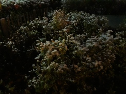
And, yes, that is snow.
A photo from our morning walk in the 6-a.m. murk:
And, yes, that is snow.
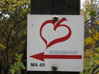
Today Maylo and I had company as we did the next stretch of the Rundumadum hiking trail. A good friend and hiking companion joined us and was a great help at seeing the Rundumadum signs. I have to confess that right towards the end we lost sight of them. We still ended up where we were supposed to, though. Since this is still a part of the Vienna Woods I know pretty well, I find myself wondering what will happen when we get to the parts I don’t know so well and can’t rely on my sense of direction, but that won’t be for several weeks yet.
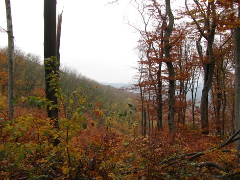
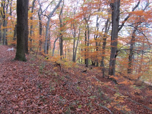
The first thing both of us commented on was how much the woods have changed in the last week. It’s suddenly gotten much cooler and the leaves are now down.
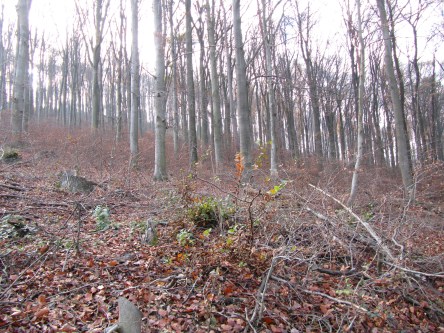
The next thing we both remarked on was how parts of the trail were completely new to us, even though we have been hiking that part of the Woods for a couple of decades. Endless variety.
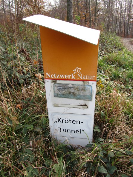
And we were delighted to see this “toad tunnel” near Schottenhof, constructed by the City of Vienna to protect wildlife. 🙂
We made it to the Feuerwache am Steinhof (fire watch and station) just in time to jump into the bus down the hill. We were very grateful for that, as the bus doesn’t run very often on that stretch.


Back to my place then for coffee, cake, and a chat.
Distance: 5 km (actually a little more because we walked from the 43 tram to Marswiese instead of taking the bus)
Time: About 2 hrs.
It wasn’t clear if we were going to continue our hike around Vienna today, but after I took a look this morning at how much I have to do this coming week and the week after (way too much), I decided this was the best way to make the most of our Sunday.
This is a route we know well. We have walked it often in the other direction, where it is disguised as Stadtwanderweg 3 (City Hiking Path 3). Again, it was strange taking the bus up the Höhenstraße. It almost feels like cheating and, on top of that, I realized today how much I actually enjoy the exertion of walking uphill. Ah, well. Another time. 😉
Here is finally a photo of the Häuserl am Roan (our starting point today) and the view from their front garden:


(The photos are gray because the weather is gray today.)
The bus was quite full, but there appeared to be very few people out. I thought with some relief that perhaps the density has died down as last week was a holiday weekend. Nope.
Empty as the Höhenstraße looks …


… there were plenty of people out and about.
First of all, we were almost run over by a large group of runners coming at us along the trail. Then there was the ongoing threat of the mountain bikers and Nordic walkers. And on the stretch from Hameau to Marswiese we encountered a group of at least 70 people all hiking together. That’s a big group!
Finally, we made it to Schwarzenbergallee, where at least one expects to dodge people constantly. And from there we made our way home. All in all, it was shorter and quicker than I expected.
Distance: 4.8 km
Time (without a break): 1 hr 15 mins
As I went out with Maylo for our last trip around the block, I saw this:
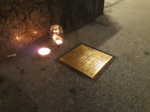
I knew it was the anniversary of Kristallnacht because it, like Hiroshima day, is part of my personal calendar. When I saw the candles next to the commemorative plaque, I suddenly realized that Kristallnacht was 80 years ago tonight. May God help us all.
As if to underline my ongoing comments about the Vienna Woods and how much greenery there is in Vienna, the site Unnutzes Wienwissen (“Vienna Trivia”) has just posted that 49.6% of Vienna’s area is Grünland: http://unnuetzeswissen.eu/wien/gruenland
Knowing that I’ll have to put my hiking on hold for a while as I am teaching all day the next three Saturdays, I decided to try at least to wrap up the first two stretches. This found Maylo and me once again on a bus on the Höhenstraße. It is a strange feeling to be whisked (and some of those bus drivers do take it at a clip in spite of the bone-shaking cobblestone surface) up a hill we usually huff and puff our way up. The bus does in 20 minutes what we usually take two to three hours for!
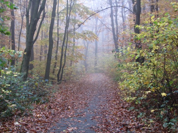
Anyway, up we went again to Cobenzl to resume our walk to Jägerwiese and beyond. I had not expected so much fog. (On the left is a photo from yesterday and on the right is a photo taken today very near the same spot.)


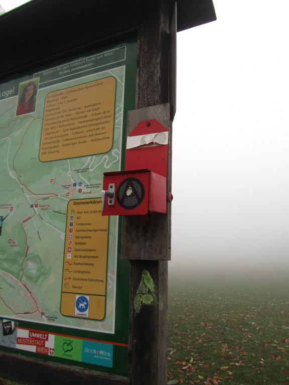
Furthermore, having noticed the fog on the way up on the bus, I would not have expected to see a lot of people, and yet there they were. Old, young, Austrian, Viennese, Polish, Hungarian, thin, sturdy, with children, without children, dressed for serious hiking, dressed to look good, with dogs, and without dogs. There were so many people that the restaurant at Jägerwiese was completely overcrowded and the wait staff rushed off their feet. Maylo and I joined a few hardy souls (the fog made it pretty chilly) on the terrace, but finally gave up any hope of getting coffee and Apfelstrudel, stamped our pass, and carried on. At least we found out what a Stempelstelle looks like. The red box contains an ink pad and the necessary rubber stamps.
Off we went again, heading towards Dreimarkstein and Häuserl am Roan, into the ever denser growing fog. I did start to wonder if it was wise, but I have to say we were not alone. Help would have been available if we had needed it.
We reached Häuserl am Roan with just a few minutes to spare before the bus got there. As it only runs once an hour on Sundays, it seemed like a good idea to catch it and come back to Häuserl am Roan another time.
An aside, Häuserl am Roan is one of the rustic restaurants offering Wiener Hausmannskost (more or less, Viennese home cooking) that dot the Vienna Woods. It has a special place in my heart because it was one of the first I discovered, many years ago. If I remember correctly, it was as I was hiking my first Stadtwanderweg (city hiking trail), Stadtwanderweg number 3, so there were two big discoveries in one afternoon.
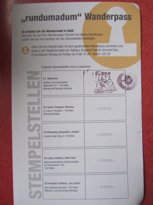
So there it is. I spent my long weekend (Friday counted as a Fenstertag or “window day,” the day between a holiday, All Saints, in this case, and a weekend) hiking with Maylo, taking photos, blogging about it, eating, and seeing friends. That’s a pretty good weekend in my book! Oh, and here is my Wanderpass with its first stamp. 🙂
Distance: 4.9 km
Time: unknown
Feeling the pressure of an unfinished route, we took the 38A back to Sulzwiese on Saturday with the best intentions. Since we were only going to do the last two to three kilometers of the first stretch, I planned to carry on from Cobenzl and do the approximately five kilometers of the next stretch (Cobenzl to Häuserl am Roan). We all know, however, where good intentions lead. By the time we had made it prematurely to Jägerwiese (having missed another of the little signs) and retraced our steps part of the way to get to Cobenzl, I again felt we had done enough. It was too discouraging to turn around and go back to Jägerwiese (a Stempelstelle, more about that below) on the same day.
We saw some beautiful views, but it did seem like a lot of traveling for not much walking!
About Stempelstellen: The City of Vienna wishes to encourage people to use the hiking paths in the Vienna Woods (and are wildly successful in their attempts if the number of people we see each time we go out is anything to go by). Part of the tradition is to offer a Wandernadel (a “hiking pin” in silver or gold depending on the level of achievement), and the way you get your pin is to stamp your Wanderpass as you make it to various Stempelstellen and send in your pass when you have filled it in. More about that in the next post, in which we go back to the Jägerwiese and get our first stamp.
Distance: 2.6 km (est.)
Time: unknown
Technically this is the first stretch of the Rundumadum hiking trail, even if it was the second for us. And–confession is good for the soul–I have to say that we did this one in two parts: Nussdorf – Sulzwiese on Thursday (All Saints, a holiday in Austria) and then Sulzwiese – Cobenzl on Saturday. Why? I think I got tired of stumbling around in a part of the Vienna Woods I actually know quite well looking for the little trail markers (see below) and bailed out, catching the 38A back to Grinzing.
We started at Nussdorf, as prescribed and walked along the Donaupromenade, a beautiful path along the Danube I had never been on before. What I was missing!


We went along to Kahlenbergerdorf. I have been there before but mainly know it from looking down from a path I’m fond of through the vineyards on Nussberg. This is what it looks like from sea level, so to speak. And, yes, despite its rusticality it is part of Vienna (19th district).


Then began the walk up Leopoldsberg along the “Nasenweg” (“Nose path”?). I have walked down the Nasenweg before but never up, and I don’t expect to do it again. It is hard work! Thank goodness the views are beautiful, with the vineyards (see above) on one side and the Danube on the other. (I intentionally didn’t write “on the right” and “on the left” as that alternates as the path snakes its way up the hill.)
At the top, there is a small castle with great photo ops and, in this case, someone I know and hadn’t seen in many years, who greeted me with “What are you doing in Vienna?” “Um, I (still) live here.” Wien ist, as we say, ein Dorf or Vienna, in spite of its 2 million inhabitants, is a village, and you really can’t go anywhere without running into someone you know.
Maylo and I then carried on our way to the next landmark (Josefinenhütte), and she went her’s. At the Josefinenhütte I think we lost our way a little. We ended up where we were supposed to–Sulzwiese–but I’m pretty sure we didn’t take the intended path. (Missed those little trail markers again!) Nonetheless, I make no apologies because I have walked down the Höhenstraße from Kahlenberg to Sulzwiese, and it is a lot easier and maybe shorter than what we did on Thursday. Although the path we took wins for beauty, I think.
That’s Maylo on the left, by the way, my wonderful hiking companion.
We wandered through these gorgeous woods, taking in the scent of late fall and reveling in the sounds of our feet in the leaves, until we got, as mentioned, to Sulzwiese and I decided we had done enough.
Off to the nearby 38A bus stop and back to town!
Distance: 5 km (est.)
Time: unknown
This is actually the 24th and last stretch of the Rundumadum hiking trail around Vienna, but it is where we started a little over two weeks ago. The weather was beautiful, although really too hot for the time of year, and I got sun and wind burn!
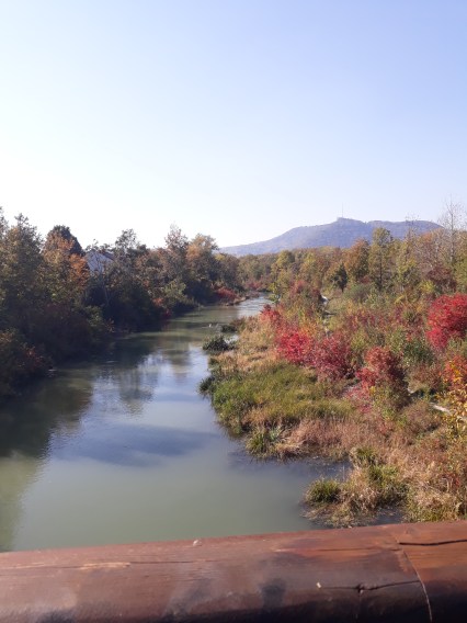
This stretch is 6.8 kilometers (which is longer than it sounds!) and starts in Vienna’s 21st district with a walk along this little river or canal in the direction of the Danube. It was special to see the red foliage as fall in Vienna is dominated by spectacular golds and yellows–beautiful in its own way but a bit strange for a New Englander. And it was quite something for me to re-visit this part of Vienna, where I used to come quite often to run courses at companies like Alcatel and Siemens that no longer have offices there.
As we got closer to the Danube there was some uncertainty how we should carry on. (Maps of the Vienna hiking trails are not always easy to follow and can lead to some adventures.) We spent some time rather nervously walking parallel to the Autobahn until we came to a bridge that let us cross that and walk along the (New) Danube instead. Ah, much better!


Then we walked along wondering if we had somehow missed the Jedleseer Bridge that would get us across to the Danube Island. Luckily we hadn’t. We found it and managed to cross, with some resistance from Maylo (it was really windy and a bit scary for a little dog). We transversed the Island, enjoying a bit of Vienna we had never been to before, and continued south to cross the Danube itself on the North Bridge–another adventure for Maylo–and wove our way around the flyovers and bike paths and canals on rather complicated and confusing footpaths to finally near our destination, passing on our way the Vienna Model Basin Ltd. (how they get that name from “SCHIFFBAUTECHNISCHE VERSUCHSANSTALT IN WIEN GMBH” somewhat mystifies me, but never mind), a lock, and various other rather industrial but, as is often the case in Vienna, also rather elegant constructions. There are some photos here for those who wish to take a look, along with an explanation in German.
Finally, we managed to cross the canal and come out on the other side in Nussdorf as we were meant to do. Success! And this inspired us (I hope Maylo agrees, I’m kind of assuming he does) to carry on and try to walk the whole way around Vienna on this trail.
Distance: 6.8 km
Time: unknown
It is (still) autumn and for me, after so many years of living according to the academic calendar, it is (still) the time to start new endeavors.
In my last post, I said I’d like to start exploring the neighborhoods around underground (subway / metro) stations I don’t know. Rather without meaning to, I seem to have started a second project along the same lines. I have done two sections of the Rundumadum hiking trail, the trail that takes you through Vienna’s “Grüngürtel” or “green belt”, and am thinking I’d like to walk the whole thing.


Stay tuned and keep an eye out for the dedicated tag “Rundumadum”.
